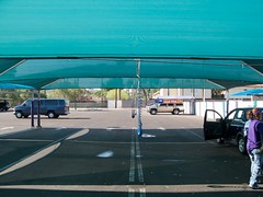
This permanent tent has shade, a misting system, and blowers that they use to blow the water out of the crevices of your car so the water doesn’t come out of the crevices while you’re driving and leave water spots. Interestingly, you can see the tent in the satellite image of this geo-location if you click the map link. I’d say my GPS data logger captured my location almost perfectly for this photo.
To explain my workflow on this public, geotagged photo:
I bought a GPS data logger called the AMOD Photo Tracker AGL3080 for $69. All it does is record location from second to second. I synchronized the clock on my camera to the clock on my computer (which is automatically synchronized to an atomic clock). When I got ready to start shooting, I clipped my Photo Tracker on my belt with the carabiner that came with it, and turned it on. I took all the photos I wanted to take, and when I was finished, I turned off the Photo Tracker. When I got home, I hooked up the GPS unit to my computer via USB and dragged and dropped the log onto my desktop (the device shows up on my Mac as an external drive). Then I put my camera’s SD card into a card reader and connected it to my Mac via USB (it shows up on my Mac as an external drive as well). I dragged and dropped all my photos from the shoot into a folder on my desktop.
Now that I had the photos and the tracklog in my computer, I launched a freeware app called GPS Babel+ and opened the NMEA log and converted it to a GPX XML file. Then I launched another freeware app called GPSPhotoLinker and I loaded the GPX file and the .CR2 (Canon Raw) photo into the app, and I had the app insert the geodata into the EXIF of all the RAW photos.
I then imported the geotagged RAW photos into Aperture, where I added keywords, version names, and captions– which show up on Flickr as tags, titles, and descriptions respectively (GPSPhotoLinker automatically added the tags Phoenix, Arizona, and United States). I made whatever images adjustments I wanted to. Finally, I used the Aperture FlickrExport plug-in to upload this photo to Flickr and the photo automatically showed up on the map.
I’ve been manually geotagging for months now by using the Flickr Organizr to drag my photos onto the map, and as complicated as the above process might sound to you, I assure you that this new process is much less time consuming and much more accurate.

Comments welcome